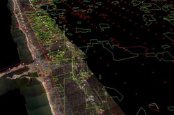
Add-on:Hurricane Katrina Damage estimates
From World Wind Wiki
| Hurricane Katrina Damage estimates, NGA delineation of Katrina Damage | |
|---|---|
| Hurricane Katrina Damage estimates
| |
| Developer | MangoCrate |
| Latest release | 1.0 / 2005-09-19 |
| License | undefined |
| Web site | NOAA |
This layer is a good way to view some of the damaged areas when used in conjunction with the NOAA Hurricane Photography addon or the Katrina NOAA/USACE aerial photo addon. This add-on was created from the NGA's damage assessment of the Gulf region.
The following classes/layers are displayed in the add-on:
- Catastrophic
- Most solid and all light or mobile structures destroyed.
- Extensive
- Some solid structures are destroyed; most sustain exterior and interior damage (e.g., roofs missing, interior walls exposed); most mobile homes and light structures are destroyed.
- Moderate
- Solid structures sustain exterior damage (e.g., missing roofs or roof segments); some mobile homes and light structures are destroyed, many are damaged or displaced.
- Limited
- Generally superficial damage to solid structures (e.g., loss of tiles or roof shingles); some mobile homes and light structures are damaged or displaced.
- Flood
- Saturation
- Impassable Roads
- Impassable Rails
- Impassable Bridges
The data was interpreted on 9/8 for the bridges, rails, roads, and 9/10 for the rest.
Links


