3D Cross Section plugin and viewer
From World Wind Wiki
| 3D Cross Section plugin and viewer | |
|---|---|
| 3D Cross Section plugin and viewer
| |
| Developer | Patrick Murris |
| Latest release | 1.4 / Nov, 2006 |
| License | Public domain |
| Web site | Plug-in Website |
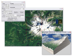
This plug-in allows you to select a square area of terrain and view the 'cut-out' in a separate 3D window - the terrain viewer.
The 'terrain extraction' and SRTM .bil export plugin was written by withak.
The 3D window is the 'Mini terrain viewer' I've been working on at times, and made better for the occasion. It can be used outside WW. You can load previously saved cross sections, and even view the SRTM tiles in WW cache by dropping them over. You can also apply different color schemes...
Contents |
Installation
Download 3D Cross Section plugin and viewer and copy the contents to your WorldWind\Plugins directory, before loading World Wind.
To use the plug-in load World Wind, open the Plug-Ins menu and click Load/Unload... (see figure 1).
Click on the Plugin in the Plugin Load/Unload window and then press the Load button (see figure 2), the indicator next to the plugin should turn green, you can now safely close the Plugin Load/Unload window.
Usage
- 1. Navigate to the place you want to cut out - with a vertical view
- 2. Click Plugins / 3D Cross section... to select the area.
- 3. Adjust the selection size and heading, move the terrain and recenter...
- 4. Enter a file name with no extension Ex: "My_Terrain", enter a short description
- 5. Click 'View selection' and be ready to wait a bit... (10... 20 sec)
- 6. Once the terrain viewer comes up, you can examine the terrain section as in WW and change the color schemes by using the Textures and Sides menus.
Some keyboard controls (more here) :
   * Shift + / - : change camera field of view (zoom)
   * Ctrl + / - : change terrain vertical elevation factor
Notes
Extracting large DEMs and large images can take several minutes and may come out incomplete.
Large DEMs need WW to have loaded in memory hi res terrain data to provide the requested resolution to build the exported DEM. If this data is not available in WW memory, the exported terrain may contain 'flat' areas.
Large images (2048x2048) require WW to have in its cache the appropriate levels needed to assemble the exported texture. If some tiles are missing, they will come out as 'white' areas.
To export succesfully large terrain sections with large textures, it is a good idea to spend some time navigating at low altitude over the area to be exported to make sure both SRTM (DEM) data are loaded in memory and hi res images are in the cache.
External Links
See also
- Stars3D plug-in. A subset of the Hipparcos catalog as star background.
- Sky and Fog plug-in. Sky dome and haze effect
- Globe icon plug-in. Adds a mini globe and overview window.
- Compass rose plug-in. Adds a compass to World Wind.


