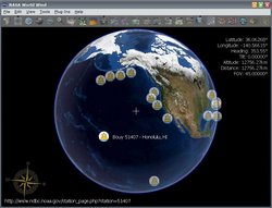
Add-on:NOAA DART
From World Wind Wiki
| NOAA DART | |
|---|---|
| DART add-on
| |
| Developer | TomServo |
| Latest release | 1.0 / 2006-04-21 |
| License | Shareware |
| Web site | Add-on website |
Description
The NOAA DART (Deep-ocean Assessment and Reporting of Tsunamis) Project is part of the U.S. National Tsunami Hazard Mitigation Program (NTHMP), an ongoing effort to maintain and improve the capability for the early detection and real-time reporting of tsunamis in the open ocean.
This add-on displays the locations of the 16 current bouys that are located around North America, clicking on the bouy marker will take you to the real-time data page where you can get the current water column depth at that location.
Links
- Download here: NOAA DART Add-on
- World Wind Forums Thread
- Add-on website


