From World Wind Wiki
[edit] Step-by-Step instructions with examples
The Degree Confluence 48°N 122°W is located to the east of Seattle, Washington state, USA.
Using this link should open World Wind, and have it centered on 48°N 122°W, at an elevation of 10,000 meters. If the link doesn't work for you, open World Wind, enable Lat/Long lines, and use them to guide you in getting to 48°N 122°W, and then zoom in to about 10,000 meters elevation.
You should enable Lat/Long lines(F7) and/or Cross Hairs(F9), and the Position display(F10).
Select the USGS Digital Ortho layer as the layer you want to display. Also known as the USGS 1m Ortho layer.
Unless you already have the data in the cache on your hard disk, World Wind should now download the layer data from the servers. That includes both the aerial photograph images from Terraserver and the terrain height data (i.e. elevation data) from NASA.
You should now wait for World Wind to complete the data downloads. The amount of time will vary depending on the speed of your Internet connection and the load on the servers. While writing this, it took seven minutes to download all the data for this first example, using a PC on a high-speed connection.

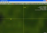
An example of what you will see during the USGS Digital Ortho data download for 48N 122W
The "Terrain Elevation" is showing a value because terrain height data has been downloaded. The "USGS logo" in the lower right corner indicates World Wind is currently downloading USGS data. The red lines indicates that the current image tile that is being downloaded covers the lower right portion of the displayed area. The upper right portion of the displayed area has a clearer image, because World Wind has already downloaded the best aerial photo data for that area for use in displaying the view from the current elevation of 10,000 meters.

An example of the display after the USGS Digital Ortho data download for 48N 122W is complete
Once the USGS Digital Ortho data has finished downloading you should see a display similar to this example. In this example, Lat/Long lines, Cross Hairs, and Position are enabled.
Now select the USGS Topo Maps layer as the layer you want to display.
An example of the 'fuzzy background' before the current layer's data is downloaded
The display will start as just a 'fuzzy background', which is actually the World Wind
Blue Marble layer zoomed in 'too far'. The data download may take some time, but this time World Wind doesn't have to download any terrain height data, because it will use the same data downloaded when the USGS Digital Ortho layer was being downloaded.

An example of the display after the USGS Topo Maps data download for 48N 122W is complete
Once the USGS Topo Maps data has finished downloading you should see a display similar to this example. In this example, Lat/Long lines, Cross Hairs, and Position are enabled.
Now select the USGS Urban Area Ortho layer as the layer you want to display. The display will start with the fuzzy Blue Marble display, and may take a while, but the terrain height data doesn't need to be downloaded.

An example of the display after the Urban Area Ortho data download for 48N 122W is complete
Once the Urban Area Ortho data has finished downloading you should see a display similar to this example. In this example, Lat/Long lines, Cross Hairs, and Position are enabled. Parts of the display are "blank" because the USGS Urban Areas data only covers specific parts of the USA. World Wind gets the USGS Urban Areas data from Terraserver. Terraserver gets the data from the USGS. The USGS website has information about their
High Resolution Orthoimagery. They also have a list that shows
what areas are covered. Terraserver has to get the data from the USGS, and process it before it becomes available on Terraserver, so there may be differences in what is available in World Wind, both in regards to the areas covered by the Urban Areas data, and as far as the resolution of the available data.
As a comparison with the USGS layers, select the NLT Landsat7 (Visible Color) layer as the layer you want to display.

An example of the display after the NLT Landsat7 (Visible Color) data download for 48N 122W is complete
This layer is an image created from digital data collected by the Landsat7 satellite. The USGS Digital Ortho and Urban Area Ortho layers are images created from aerial photographs.
Each layer has different characteristics, including the "usable" resolution for the layer. The NLT Landsat7 (Visible Color) data has a resolution of 30 meters per pixel, so each pixel in the image represents 30 meters on the ground. The USGS Digital Ortho data has a resolution of 1 meter per pixel. The Urban Area Ortho data resolution is less than one metere per pixel. Another difference between layers may be the date when the data was collected, so you may see features that are different when comparing layers.
Select the USGS Digital Ortho layer as the layer you want to display.

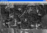
An example of the display after zooming in on the USGS Digital Ortho data to an Altitude of 550m above 48N 122W
Now zoom in from the current Altitude of 10,000 meters to as close as you can get to the earth, which is an Altitude of 550 meters. When zoomed in to this level, the display is blurred because you have zoomed past the "useable" resolution of this layer's data.
An example of the display showing the USGS Digital Ortho data at an Altitude of 1100m above 48N 122W
Now zoom out so the Altitude is about 1100 meters above 48°N 122°W. The "cross" in the middle of the display is part of the images retrieved by World Wind from Terraserver, and represents the location 48°N 122°W. You can confirm this by enabling Lat/Long lines(F7), or Cross Hairs(F9) and Position(F10).
At this point the display in World Wind is equivalent to "looking straight down" from 1100 meters above 48°N 122°W. Of course you can do things in World Wind such as rotating the view to see the terrain features, but the "view from above" is essentially the same as can be displayed directly using the Terraserver website. From the webpage for the 48°N 122°W Degree Confluence if you select the "aerial" maps link, you will go to a Terraserver page that shows essentially the same view as the above World Wind example. This Terraserver page shows that the data was collected July 25, 1998 (7/25/1998). The info link shows that the resolution of the image is 1 meter per pixel.
Now select the USGS Topo Maps layer as the layer you want to display. At the current Altitude of 1100 meters, the display of the topographic map is blurred because you are zoomed past the "useable" resolution of this layer's data.

An example of the display showing the USGS Topo Maps data at an Altitude of 2000m above 48N 122W
Now zoom out so the Altitude is about 2000 meters above 48°N 122°W. The "cross" in the middle of the display is part of the images retrieved by World Wind from Terraserver, and represents the location 48°N 122°W. You can confirm this by enabling Lat/Long lines(F7), or Cross Hairs(F9) and Position(F10).
While still at the 2000m Altitude, select the USGS Urban Area Ortho layer as the layer you want to display.

An example of the display showing the USGS Urban Area Ortho data at an Altitude of 2000m above 48N 122W
You will have to wait while World Wind downloads data for that layer. Portions of the display should start out being "a bit fuzzy", then get sharper as the data tiles are downloaded, and end up being quite sharp. Unlike the USGS Digital Ortho and USGS Topo Maps images, this layer's data doesn't have a "cross" marking the location of 48°N 122°W.

An example of the display after zooming in on the USGS Urban Area Ortho data to an Altitude of 550m above 48N 122W
Now zoom in from the current Altitude of 2000 meters to as close as you can get to the earth, which is an Altitude of 550 meters.
NOTE: There is currently(March 9, 2005) an issue where the resolution of the USGS Urban Area Ortho images available through World Wind v1.3 is not as good as is available from the Terraserver website, or even what was available using World Wind v1.2, and this issue is being investigated.
[edit] See Also


